信息图与教育
信息图可视化设计
原文3,492 个字符
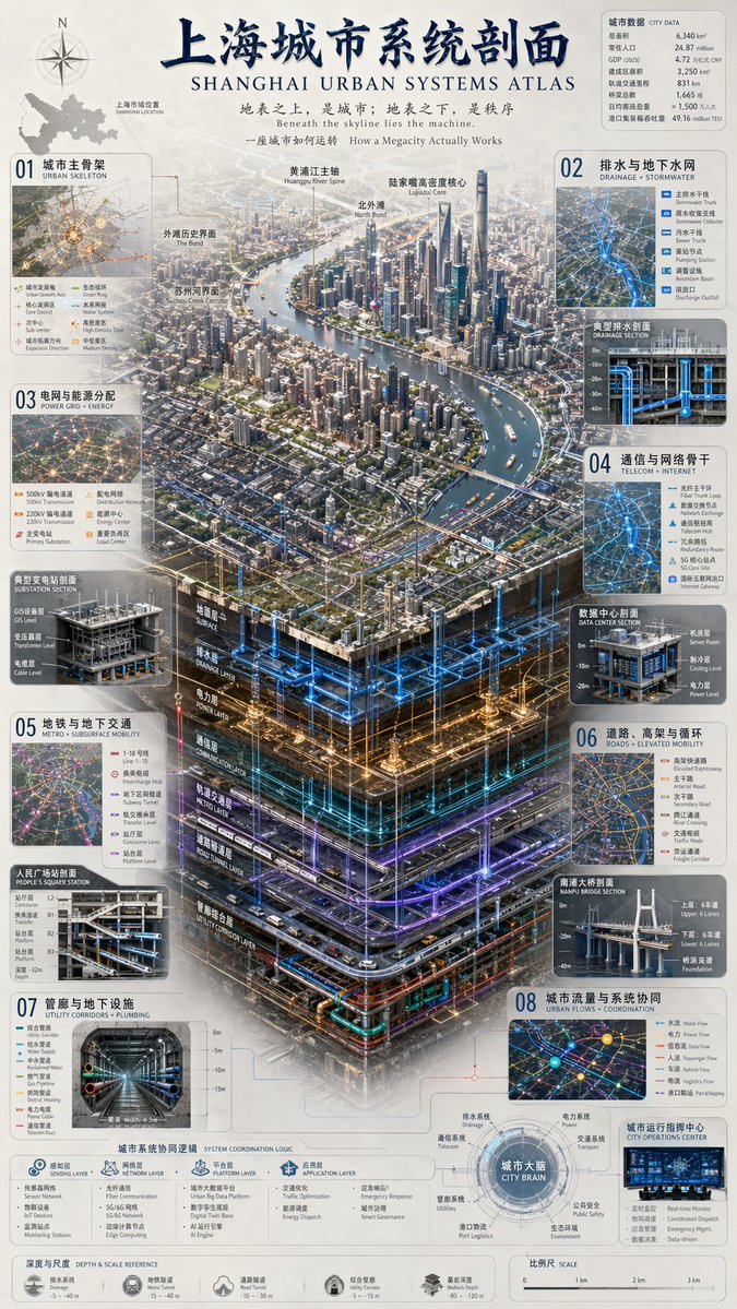
{
  "type": "complex urban systems atlas infographic",
  "style": "{argument name=\"color palette\" default=\"dark background with glowing blue, gold, and purple accents\"}, highly detailed technical illustration, 3D isometric cutaway",
  "header": {
    "title": "{argument name=\"chinese city name\" default=\"上海\"}Urban Systems Profile {argument name=\"english city name\" default=\"SHANGHAI\"} URBAN SYSTEMS ATLAS",
    "subtitles": [
      "Above ground is the city; below ground is order {argument name=\"english subtitle\" default=\"Beneath the skyline lies the machine.\"}",
      "How a Megacity Actually Works"
    ]
  },
  "layout": {
    "top_left": "Compass rose and city map labeled 'Shanghai City Location SHANGHAI LOCATION'",
    "top_right": "Data table titled 'City Data CITY DATA' with 7 rows of statistics",
    "centerpiece": {
      "description": "{argument name=\"centerpiece style\" default=\"highly detailed 3D isometric cutaway render\"} of a megacity river landscape",
      "layers": [
        "Surface Layer SURFACE",
        "Drainage Layer DRAINAGE LAYER",
        "Power Layer POWER LAYER",
        "Communication Layer COMMUNICATION LAYER",
        "Metro Rail Layer METRO LAYER",
        "Road Tunnel Layer ROAD TUNNEL LAYER",
        "Utility Corridor Layer UTILITY CORRIDOR LAYER"
      ]
    },
    "side_panels": [
      { "id": "01", "title": "Urban Main Framework URBAN SKELETON", "elements": "Map with 8 legend items" },
      { "id": "02", "title": "Drainage and Groundwater Network DRAINAGE + STORMWATER", "elements": "Cross-section diagram 'Typical Drainage Profile DRAINAGE SECTION' with 5 legend items" },
      { "id": "03", "title": "Power Grid and Energy Distribution POWER GRID + ENERGY", "elements": "Cross-section diagram 'Typical Substation Profile SUBSTATION SECTION' with 6 legend items" },
      { "id": "04", "title": "Communication and Network Backbone TELECOM + INTERNET", "elements": "Cross-section diagram 'Data Center Profile DATA CENTER SECTION' with 6 legend items" },
      { "id": "05", "title": "Metro and Underground Transportation METRO + SUBSURFACE MOBILITY", "elements": "Cross-section diagram 'People's Square Station Profile PEOPLE'S SQUARE STATION' with 6 legend items" },
      { "id": "06", "title": "Roads, Elevated Roads and Circulation ROADS + ELEVATED MOBILITY", "elements": "Cross-section diagram 'Nanpu Bridge Profile NANPU BRIDGE SECTION' with 6 legend items" },
      { "id": "07", "title": "Utility Corridors and Underground Facilities UTILITY CORRIDORS + PLUMBING", "elements": "Cross-section diagram 'Comprehensive Utility Corridor UTILITY CORRIDOR' with 8 legend items" },
      { "id": "08", "title": "Urban Flows and System Coordination URBAN FLOWS + COORDINATION", "elements": "Map diagram 'City Operations Center CITY OPERATIONS CENTER' with 6 legend items" }
    ],
    "bottom_panels": {
      "system_logic": {
        "title": "Urban System Coordination Logic SYSTEM COORDINATION LOGIC",
        "steps": 4,
        "labels": ["Sensing Layer SENSING LAYER", "Network Layer NETWORK LAYER", "Platform Layer PLATFORM LAYER", "Application Layer APPLICATION LAYER"]
      },
      "city_brain": {
        "title": "Urban Brain CITY BRAIN",
        "central_node": 1,
        "peripheral_nodes": 8
      },
      "references": {
        "depth_scale": { "title": "Depth and Scale DEPTH & SCALE REFERENCE", "icons": 5 },
        "map_scale": { "title": "Scale SCALE", "markers": 4 }
      }
    }
  }
}